Would municipal workers be more inspired and productive, and politicians more informed and less corrupt, if they worked inside a building similar to some of the beautiful city halls shown in the link below? For the record, I think the examples from Dallas and San Jose are quite ugly.
http://www.governing.com/topics/transportation-infrastructure/gov-big-bold-city-halls.html
Sure, to some extent, good architecture and aesthetic beauty
is subjective. But would anyone really argue that the Indianapolis
City-County Building could be inserted into a list of great city halls
as anything other than a silly joke? Or that Indianapolis is a better
city for having vacated the old city hall and county courthouse (seen below before being demolished) in favor of the City-County Building constructed in 1962.
http://historicindianapolis.com/a-room-with-a-view-city-county-observation-deck-western-view/
It's probably not too controversial to opine that Indianapolis's image, and more importantly its collective civic pride, would've thrived more by maintaining its old city hall and county courthouse. (The old city hall building lives on, having served as the Indiana State Museum and interim home for the Indianapolis-Marion County Public Library, but has been neglected for several years despite a recent plan to move a few city planners to a small portion of the building. The county courthouse was demolished shortly after construction of the existing city-county building.) But more interestingly, this made me wonder whether the replacement of these two beautiful buildings with one bland structure could be viewed as a precursor to the quality of both private and public development that followed the merger of the city and county governments under the moniker of "Unigov" starting around 1970.
What inspirational development has occurred in the consolidated city of Indianapolis in the last 40 years? I didn't live here in the '70s, '80s, or '90s, so maybe someone else would be better suited to provide examples, but I can't think of much that appears to be from that era other than a few run-of-the-mill office skyscrapers, plenty of strip malls, a plethora of "big-box" stores and indoor shopping centers surrounded by dozens or hundreds of acres of surface parking (typically with scant, if any, landscaping), and endless residential developments with substandard infrastructure (missing sidewalks, curbs, street lighting, etc.) and uninspired building design. Clearly, these three decades didn't seem to produce much of anything that we will collectively be sad to see disappear whenever it deteriorates and is eventually abandoned and redeveloped.
Has the 21st Century provided a turning point for Indianapolis in how its development inspires collective pride, and hopefully civic engagement? The downtown Fieldhouse (currently sponsored by Bankers Life), Lucas Oil Stadium, the expanded Indiana Convention Center; do these buildings inspire us and will we take in pride and maintaining and preserving them for many decades or centuries to come? Downtown's Cultural Trail has widely received accolades from around the country. Will this lead to a strong demand for better public streets throughout Indianapolis in place of the horrendous roads, designed mostly to move cars as quickly as possible with little, if any, consideration given to anyone outside of a car, that predominate the landscape?
Did the consolidation of the old city limits of Indianapolis with the sparsely developed outer portions of Marion County lead to a watering down of expectations for private development, government action, and public participation? While I've long supported the idea that local government consolidation can provide many benefits through efficiency and creating a more equitable property tax base, I can't help but wonder whether, in the case of Indianapolis, that a smaller jurisdiction might've resulted in better public development as citizens might've had an easier time interacting and engaging with a smaller local government, and the government might've been more inclined to seek public input to ensure that projects were well suited to the diversity of neighborhoods found in a 400-square mile county. If most of your votes are coming from very different, far-away neighborhoods, it might not come as a surprise that politicians don't make public input in those areas a priority. Certainly, it's at least a little bit harder to create appropriate street designs in a consolidated county that includes typical urban, suburban, and rural areas, than it would to do for just one of the three. Maybe I'm just looking for an explanation to excuse Indianapolis's woefully inadequate street designs that have only recently started to show limited signs of improvement. Nonetheless, it's well beyond time for Indianapolis to make a habit of inspiring citizens and visitors with its public development, which might result in better private development as well.
Tuesday, November 12, 2013

Monday, October 7, 2013
I live in ___________, but I have a _____________ address.
Well, it's been quite some time since I made an entry. Beginning now, I plan to add entries several times a week, so cue the excitement.
For my return to the blogosphere, I ease back into things by tackling a fairly light subject regarding addresses. When I moved to Indiana, I was confused to hear people say something like "I live in Indianapolis, but I have a Zionsville address." What in the heck does that mean?!? You live where you live. If you live in Indianapolis, how can you possibly have anything other than an Indianapolis address?
Perusing the real estate ads today, I saw a listing for a house in Hamilton County near 102nd St & College Avenue. The house was clearly north of 96th Street which is the Marion-Hamilton county line. We all know that Indianapolis does not extend into Marion County and this area north of 96th Street near College Avenue is within the City of Carmel. Yet, the real estate listing indicated that the house had an Indianapolis address but was in the Carmel-Clay school district.
How is it that a house in the City of Carmel has an Indianapolis address? I suspect that perhaps it has something to do with where the post office is located for that particular zip code. What I don't get is why people have come to believe that their address might be different than the reality of where they live. If you live at 102nd & College and give out your address as 10200 N College Ave, Carmel IN 46280, is your mail not going to be delivered because you are told that you have an Indianapolis address, not a Carmel one? I can't imagine it wouldn't get delivered. I always thought that, with the advent of zip codes, the city listed on your address really wasn't relevant since it would be so highly improbable that there the same street address would exist in two municipalities that share a zip code. In fact, when I once lived in the Twin Cities suburb of Apple Valley, I would often, just for fun, give out my address as being in St. Paul and was not aware of any issues whatsoever with getting my mail successfully delivered.
I don't get it. I even recall people saying that certain neighborhoods were more desirable because they had addresses in a particular municipality even though it was known that they were actually within a different municipality. I certainly want to believe that the post office is capable of delivering mail to two different municipalities within the same zip code. Is there something unique about Indiana and this phenomenon of living in one municipality, but having an address in a different municipality? Please clue me in and/or let me know if I'm wrong on this one.
For my return to the blogosphere, I ease back into things by tackling a fairly light subject regarding addresses. When I moved to Indiana, I was confused to hear people say something like "I live in Indianapolis, but I have a Zionsville address." What in the heck does that mean?!? You live where you live. If you live in Indianapolis, how can you possibly have anything other than an Indianapolis address?
Perusing the real estate ads today, I saw a listing for a house in Hamilton County near 102nd St & College Avenue. The house was clearly north of 96th Street which is the Marion-Hamilton county line. We all know that Indianapolis does not extend into Marion County and this area north of 96th Street near College Avenue is within the City of Carmel. Yet, the real estate listing indicated that the house had an Indianapolis address but was in the Carmel-Clay school district.
How is it that a house in the City of Carmel has an Indianapolis address? I suspect that perhaps it has something to do with where the post office is located for that particular zip code. What I don't get is why people have come to believe that their address might be different than the reality of where they live. If you live at 102nd & College and give out your address as 10200 N College Ave, Carmel IN 46280, is your mail not going to be delivered because you are told that you have an Indianapolis address, not a Carmel one? I can't imagine it wouldn't get delivered. I always thought that, with the advent of zip codes, the city listed on your address really wasn't relevant since it would be so highly improbable that there the same street address would exist in two municipalities that share a zip code. In fact, when I once lived in the Twin Cities suburb of Apple Valley, I would often, just for fun, give out my address as being in St. Paul and was not aware of any issues whatsoever with getting my mail successfully delivered.
I don't get it. I even recall people saying that certain neighborhoods were more desirable because they had addresses in a particular municipality even though it was known that they were actually within a different municipality. I certainly want to believe that the post office is capable of delivering mail to two different municipalities within the same zip code. Is there something unique about Indiana and this phenomenon of living in one municipality, but having an address in a different municipality? Please clue me in and/or let me know if I'm wrong on this one.
Tuesday, November 6, 2012
Election 2012
As President Obama is being projected as the winner of a second term in the White House, I am watching scenes of people dancing in the streets near Times Square, and I am thinking: what is wrong with these people? What could they possibly be so excited about? The only result that I can imagine that could've actually been worse than this, is if Romney had won.
Sunday, December 12, 2010
10th & Bellefontaine
Walked around in the snow this afternoon at this newly completed (?) intersection which serves as the terminus of the northeast leg of the Cultural Trail. I appreciate the apparent efforts to make the intersection more hospitable to pedestrians, however, a few parts of the design seem odd and confusing. First, the right lane of eastbound 10th Street ends, just prior to the intersection instead of being a right-turn only lane onto Bellefontaine. I guess I don't object to eastbound through traffic and the occasional right-turning vehicle sharing the same lane, but I hope that on-street parking will be permitted in the right lane between College and Bellefontaine as I believe it is west of College. What's really strange to me is the right-turn lane from northbound Bellefontaine to eastbound 10th Street. After a vehicle begins into the rounded right turn lane that is designed to accommodate turns at a much faster speed than a regular right turn, the driver encounters a traffic signal.
There's no sign indicating that the right turn can't be completed without waiting for a red light, but I presume that's the point since a crosswalk runs right in front of the stop line. All of the drivers I witnessed proceeded through the right turn without waiting for a green light, most not even stopping for the red light. It seems to me that the design of the right turn lane sends a mixed message to drivers: such rounded turn lanes are typically designed to allow right turns to occur at any time without stopping, but yet at this location where the Cultural Trail crosses 10th Street to connect to the Monon Trail, obviously, the intent was to give preference to and provide safety for pedestrians and bicyclists. The rounded right turn lane fails as the design allows vehicles to complete the turn (into a reborn eastbound 10th Street right lane) while the single lane of 10th Street traffic proceeds through the intersection as well.
At a minimum, I think there needs to be a sign prohibiting a right turn from Bellefontaine to 10th on red. However, I think that pedestrians and bicyclists would be safer if the right turn movement was a 90-degree turn that would actually require drivers to slow to a safe speed. For that matter, I'm not sure why there's no left turn permitted from Bellefontaine to westbound 10th Street. The only crosswalk is on the east side of the intersection so there'd be no conflict with ped/bike traffic, and it would certainly be helpful for someone who has been unsuccessful at finding a parking space on Mass Ave or Bellefontaine to be able to circle back around by going west on 10th and south on College. Most such drivers will be considerably inconvenienced by being required to travel east under I-70/I-65 to either then make a u-turn or a series of several turns to get back to the west side of the Interstate.
There's no sign indicating that the right turn can't be completed without waiting for a red light, but I presume that's the point since a crosswalk runs right in front of the stop line. All of the drivers I witnessed proceeded through the right turn without waiting for a green light, most not even stopping for the red light. It seems to me that the design of the right turn lane sends a mixed message to drivers: such rounded turn lanes are typically designed to allow right turns to occur at any time without stopping, but yet at this location where the Cultural Trail crosses 10th Street to connect to the Monon Trail, obviously, the intent was to give preference to and provide safety for pedestrians and bicyclists. The rounded right turn lane fails as the design allows vehicles to complete the turn (into a reborn eastbound 10th Street right lane) while the single lane of 10th Street traffic proceeds through the intersection as well.
At a minimum, I think there needs to be a sign prohibiting a right turn from Bellefontaine to 10th on red. However, I think that pedestrians and bicyclists would be safer if the right turn movement was a 90-degree turn that would actually require drivers to slow to a safe speed. For that matter, I'm not sure why there's no left turn permitted from Bellefontaine to westbound 10th Street. The only crosswalk is on the east side of the intersection so there'd be no conflict with ped/bike traffic, and it would certainly be helpful for someone who has been unsuccessful at finding a parking space on Mass Ave or Bellefontaine to be able to circle back around by going west on 10th and south on College. Most such drivers will be considerably inconvenienced by being required to travel east under I-70/I-65 to either then make a u-turn or a series of several turns to get back to the west side of the Interstate.
Tuesday, September 7, 2010
Sidewalk Reconstruction on Dr. MLK Jr. St.
Check it out! Along with resurfacing the street, the City has rebuilt many of the sidewalks along Dr. MLK Jr. Street between 16th & 21st Streets.
 The above photo is looking south on the west side of MLK, across from 17th Street. A newly constructed, smooth walking surface should enhance pedestrian safety and enjoyment.
 Unfortunately, upon closer inspection it becomes apparent that there are some serious deficiencies in the design of these sidewalks. While it would appear that the City was simply "replacing like for like", I'm not sure that exempts this project from the requirements of the Americans with Disabilities Act.
 I'm not a lawyer, so I'll not speculate on what would happen if a lawsuit were filed, but I do know that a minimum width of 36" (for one-way traffic) is required for any walkway intended for public use, and a minimum 60" path (to provide for passing) must be provided at regular intervals (something like every 100-200 feet). Thus, cities typically adopt a standard requiring a minimum 60" sidewalk width, but narrower widths can be acceptable in limited situations. Including the curb, there is 26" of space to the left of the utility pole and 21" on the right side.
 I can imagine that utility pole (and wire) relocation might be complicated and expensive. But would it have been so difficult or expensive to widen the sidewalk behind the utility poles? When the City rebuilt the sidewalk, they rebuilt the driveway in the foreground to a distance of 39" behind the sidewalk. Couldn't they have done that to provide an ADA-compliant path around the poles? As constructed, the wider path is to left of the pole, which forces someone in a wheelchair to risk falling into the street.
 There's also a fire hydrant just south of this utility pole, however, there is a 36" gap between the two, so although it would be unconventional, it would appear that an ADA-compliant walkway could have been provided, if the City had added to the width of the sidewalk where it encounters this pole.
 This photo is looking south along MLK, just south of 17th Street. This particular area of sidewalk was not reconstructed, presumably because it is in pretty good shape. That makes sense.
 But if you would make a decision to not reconstruct this sidewalk because the surface is in good shape, wouldn't you recognize that the vegetation blocking the sidewalk needs to be removed?
 The above photo is looking south on the west side of MLK, across from 17th Street. A newly constructed, smooth walking surface should enhance pedestrian safety and enjoyment.
 Unfortunately, upon closer inspection it becomes apparent that there are some serious deficiencies in the design of these sidewalks. While it would appear that the City was simply "replacing like for like", I'm not sure that exempts this project from the requirements of the Americans with Disabilities Act.
 I'm not a lawyer, so I'll not speculate on what would happen if a lawsuit were filed, but I do know that a minimum width of 36" (for one-way traffic) is required for any walkway intended for public use, and a minimum 60" path (to provide for passing) must be provided at regular intervals (something like every 100-200 feet). Thus, cities typically adopt a standard requiring a minimum 60" sidewalk width, but narrower widths can be acceptable in limited situations. Including the curb, there is 26" of space to the left of the utility pole and 21" on the right side.
 I can imagine that utility pole (and wire) relocation might be complicated and expensive. But would it have been so difficult or expensive to widen the sidewalk behind the utility poles? When the City rebuilt the sidewalk, they rebuilt the driveway in the foreground to a distance of 39" behind the sidewalk. Couldn't they have done that to provide an ADA-compliant path around the poles? As constructed, the wider path is to left of the pole, which forces someone in a wheelchair to risk falling into the street.
 There's also a fire hydrant just south of this utility pole, however, there is a 36" gap between the two, so although it would be unconventional, it would appear that an ADA-compliant walkway could have been provided, if the City had added to the width of the sidewalk where it encounters this pole.
 This photo is looking south along MLK, just south of 17th Street. This particular area of sidewalk was not reconstructed, presumably because it is in pretty good shape. That makes sense.
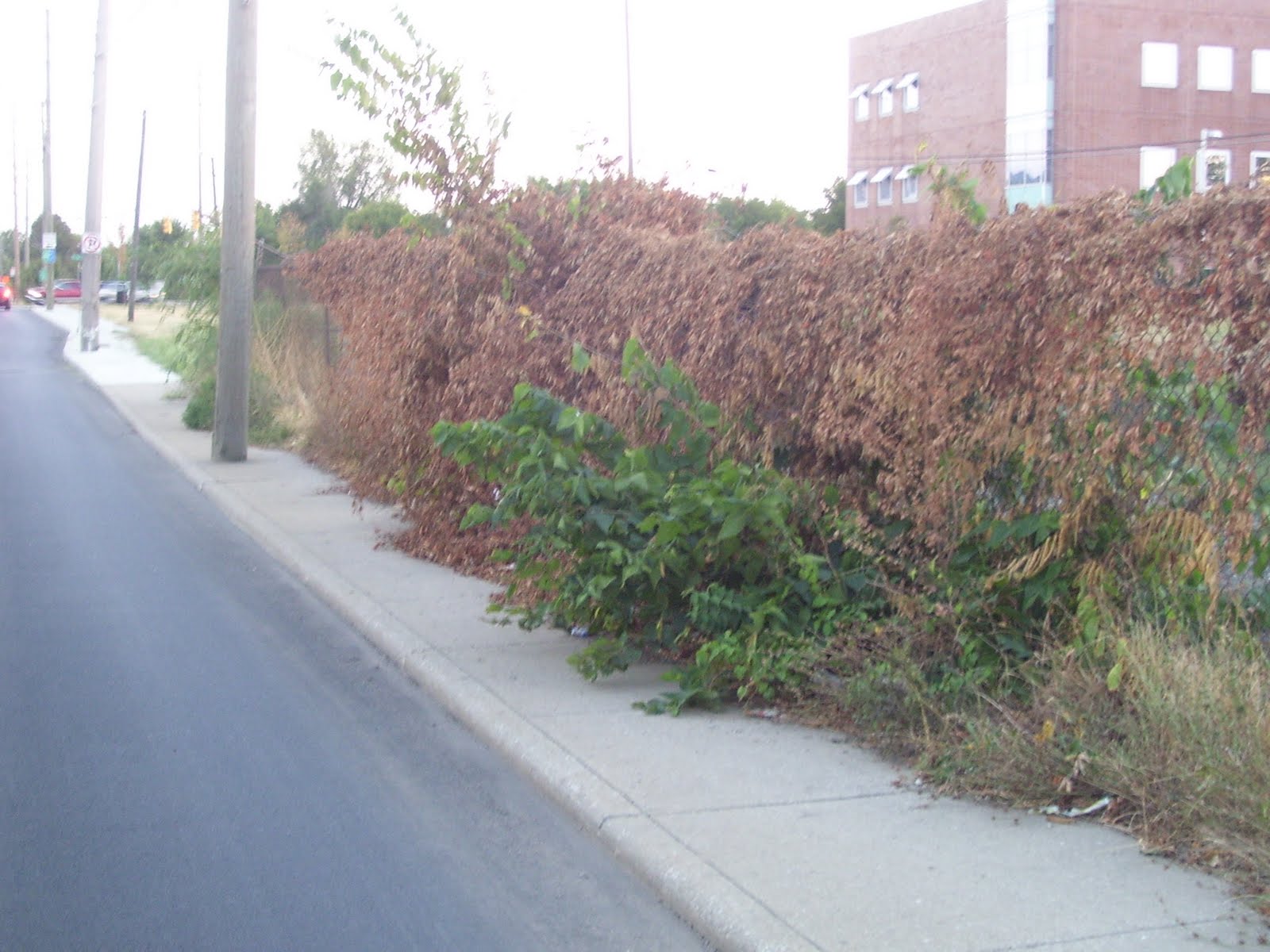 But if you would make a decision to not reconstruct this sidewalk because the surface is in good shape, wouldn't you recognize that the vegetation blocking the sidewalk needs to be removed?
Sunday, August 29, 2010
16th Street improvements
Below is a link to an article in the current issue of the Urban Times about an upcoming City project on 16th Street. It appears that the project will mainly consist of resurfacing the street, with some sidewalk and curb repair/replacement. The exciting part is the ability of a group of concerned citizens being successful in convincing the City to make some substantive changes to their plans to actually improve the street from a pedestrian's standpoint, most notably by providing curb extensions at the intersection of 16th & Delaware to reduce the crosswalk distance from five lanes to three lanes. Hopefully, this will also slow the speed of traffic and further increase safety for both drivers and pedestrians at this off-set intersection.
Ironic was the mention that the citizens' group was unsuccessful in convincing the city to reconstruct the sidewalk on the south side of 16th, west of Meridian (in front of Walgreen's parking lot), because the sidewalk there was too recently constructed to merit reconstruction. The citizens' group asked that the sidewalk be rebuilt away from the curb with a tree lawn between the street and sidewalk. One might ask why the City didn't build the sidewalk that way when it was previously reconstructed. Did we just realize that sidewalks built right next to a lane of moving cars are not inviting to pedestrians? The sidewalk probably could've been rebuilt as part of the Walgreen's redevelopment at this corner in 2007. Perhaps the City decided that it was more important to have some landscaping between the sidewalk and Walgreen's parking lot, which (according to the City's website: http://imaps.indygov.org/prod/GeneralViewer/viewer.htm ) appears to be built within a foot or so of the 16th Street right-of-way line, rather than providing a ten-foot strip of landscaping as typically required by the zoning ordinance.
Across Meridian Street, the construction of the new CVS did include reconstruction of the 16th Street sidewalk at the right-of-way line to give pedestrians a slight buffer from traffic. Unfortunately, the sidewalk along Meridian Street still hugs the curb, requiring pedestrians to walk within a misstep of traffic. While it doesn't appear that there is additional unused right-of-way on Meridian Street, there is a strip of landscaping between the CVS building and the sidewalk. Why not reverse the sidewalk and landscaping to provide some buffer between pedestrians and traffic?
http://www.urbantimesonline.com/2010/08/16th-street-getting-a-makeover-between-illinois-and-central/
Wouldn't it be refreshing to have the City actually propose improvements that would improve the pedestrian environment instead of it only happening as a result of active and informed citizens catching them in time to win some changes to the plans? Take a look at the newly rebuilt sidewalk on Dr. MLK Jr. St, between 16th and 21st Streets. Right next to moving traffic and worse yet, there are utility poles right in the middle of the sidewalk, such that there isn't even space to get a wheelchair around the poles without going off the sidewalk. Does not the Americans with Disabilities Act apply to such projects?
Ironic was the mention that the citizens' group was unsuccessful in convincing the city to reconstruct the sidewalk on the south side of 16th, west of Meridian (in front of Walgreen's parking lot), because the sidewalk there was too recently constructed to merit reconstruction. The citizens' group asked that the sidewalk be rebuilt away from the curb with a tree lawn between the street and sidewalk. One might ask why the City didn't build the sidewalk that way when it was previously reconstructed. Did we just realize that sidewalks built right next to a lane of moving cars are not inviting to pedestrians? The sidewalk probably could've been rebuilt as part of the Walgreen's redevelopment at this corner in 2007. Perhaps the City decided that it was more important to have some landscaping between the sidewalk and Walgreen's parking lot, which (according to the City's website: http://imaps.indygov.org/prod/GeneralViewer/viewer.htm ) appears to be built within a foot or so of the 16th Street right-of-way line, rather than providing a ten-foot strip of landscaping as typically required by the zoning ordinance.
Across Meridian Street, the construction of the new CVS did include reconstruction of the 16th Street sidewalk at the right-of-way line to give pedestrians a slight buffer from traffic. Unfortunately, the sidewalk along Meridian Street still hugs the curb, requiring pedestrians to walk within a misstep of traffic. While it doesn't appear that there is additional unused right-of-way on Meridian Street, there is a strip of landscaping between the CVS building and the sidewalk. Why not reverse the sidewalk and landscaping to provide some buffer between pedestrians and traffic?
http://www.urbantimesonline.com/2010/08/16th-street-getting-a-makeover-between-illinois-and-central/
Wouldn't it be refreshing to have the City actually propose improvements that would improve the pedestrian environment instead of it only happening as a result of active and informed citizens catching them in time to win some changes to the plans? Take a look at the newly rebuilt sidewalk on Dr. MLK Jr. St, between 16th and 21st Streets. Right next to moving traffic and worse yet, there are utility poles right in the middle of the sidewalk, such that there isn't even space to get a wheelchair around the poles without going off the sidewalk. Does not the Americans with Disabilities Act apply to such projects?
Monday, August 23, 2010
Pedestrian Safety Action Plan
Comprehensive study of pedestrian traffic fatalities and severe injuries in New York City:
http://s3.amazonaws.com/nytdocs/docs/458/458.pdf
UPDATE: 25-Aug-2010
This is a pretty thorough analysis of accidents involving death or severe injury. While it focuses much of its energy on pedestrians, it does analyze the rate of overall traffic deaths among all street users and determines that New York City is the safest city in the U.S. as far as traffic deaths are concerned. It adjusts for the surge in daytime population in Manhattan to stress that although the raw number of deaths and injuries is high, the rate per 100,000 population is quite low.
I believe that it alludes to NYC being even safer for pedestrians than the rate of death and severe injury per 100,000 population would imply, because there is actually a much higher rate of walking among the population there, among commuters, residents, and tourists. I've always wanted to see a study that attempts to compare pedestrian safety among U.S. cities by estimating something like miles walked per 100,000 population and using that to determine the actual likelihood of being killed or injured in a collision. My hunch has been that such a study would find that older, more dense cities, where walking is more common, are many times safer to walk in than our newer, lower density cities. It might also be interesting to have a study that factored in death or injury due to crime. If anyone is aware of such a study, please provide a link or other direction.
http://s3.amazonaws.com/nytdocs/docs/458/458.pdf
UPDATE: 25-Aug-2010
This is a pretty thorough analysis of accidents involving death or severe injury. While it focuses much of its energy on pedestrians, it does analyze the rate of overall traffic deaths among all street users and determines that New York City is the safest city in the U.S. as far as traffic deaths are concerned. It adjusts for the surge in daytime population in Manhattan to stress that although the raw number of deaths and injuries is high, the rate per 100,000 population is quite low.
I believe that it alludes to NYC being even safer for pedestrians than the rate of death and severe injury per 100,000 population would imply, because there is actually a much higher rate of walking among the population there, among commuters, residents, and tourists. I've always wanted to see a study that attempts to compare pedestrian safety among U.S. cities by estimating something like miles walked per 100,000 population and using that to determine the actual likelihood of being killed or injured in a collision. My hunch has been that such a study would find that older, more dense cities, where walking is more common, are many times safer to walk in than our newer, lower density cities. It might also be interesting to have a study that factored in death or injury due to crime. If anyone is aware of such a study, please provide a link or other direction.
Wednesday, April 14, 2010
Pedestrians struck on sidewalk
According to multiple news reports, two teenage girls walking along the sidewalk on the 2800 block of North Keystone Avenue were struck by a drunk driver Tuesday evening. The girls were severely injured and are currently hospitalized. Initial reports indicate the driver, with prior DUI convictions, who fled the scene but was apprehended shortly thereafter, is suspected of being intoxicated. Obviously, it would appear that the driver is completely responsible for this horrific tragedy. Our thoughts and prayers are with the girls and their families and friends.
However, being familiar with this street, I can't help but wonder whether a different street design could have possibly prevented these girls from being victims of this collision. Anyone who has walked this stretch of Keystone Avenue likely remembers that it is not designed to be safe or inviting for pedestrians. Sidewalks are immediately adjacent to the four-lane street, which does not permit parking on either side of the street. Although this is not an extraordinarily wide street (the lanes appear to be 10-11 feet wide), vehicles seem to typically drive in excess of the posted 35 MPH speed limit, probably because there is little to nothing of interest along or adjacent to the street to provide a natural cue to slow down.
What if the sidewalk was not directly adjacent to the street? What if pedestrians were not required to walk within a couple of feet of speeding vehicles, with nothing but a concrete curb of six inches in height or less? What if the sidewalk was separated from the street by a tree lawn? What if a tree would have been in the path of this driver and either stopped or slowed his vehicle before reaching the sidewalk?
I'm not proclaiming that if the street/sidewalk were designed differently, that this tragedy would have been avoided, but it very well might have. Quite frankly, with the widespread application of this street/sidewalk design throughout Marion County, I'm surprised that we don't hear about more pedestrians being struck. Imagine walking two abreast on a 5-foot wide sidewalk. To prevent constant shoulder/elbow bumping, one person needs to be walking just inches from the curb. One misstep, one dizzy spell, one unexpected crack in the sidewalk, could lead to a pedestrian instantly falling into the path of a moving vehicle with little to no time to react. Of course, the infrequency of such collisions could likely have a significant correlation with the fact that very few people use these sidewalks. Walking along sidewalks such as this one are typically only done by those with no other choice: no car and no other path to get where they need to go.
The solution is simple: build all sidewalks with a buffer from moving traffic. Typically, a landscape strip with trees is ideal, not only to provide a physical separation, but because it makes the street corridor more attractive to pedestrians and drivers alike and raises adjacent property values, along with all the environmental benefits. (Regularly used on-street parking can also provide a safety buffer between pedestrians and moving cars.) The Indianapolis-Marion County codes actually support the idea that sidewalks should be located with a buffer from the street, however, the City continues to build sidewalks similar to the one on Keystone Avenue.
The City is gearing up for a complete reconstruction of West 38th Street, between High School Road and I-65. The project will include construction of new sidewalks on both sides of 38th Street, but they will be immediately adjacent to the curb, forcing pedestrians to walk just a matter of inches from cars regularly traveling at 40-45 MPH, often faster. Although most of this corridor currently lack sidewalks, several portions actually include sidewalks that are buffered from the street, all of which will unfortunately be destroyed, regardless of their current condition, so that sidewalks can be rebuilt uniformly located right next to the street.
Why is the City doing this? I wish I knew. Maybe it's a buck or two cheaper to pour the sidewalk concrete right next to the curb because you only have to frame in on one side, rather than two. Although that would seem like a ridiculous reason to build an unsafe, unattractive, uninviting sidewalk, I can't think of any other reason. It's not for lack of available dedicated public right-of-way. A quick check of the General Data Viewer on the City's website shows that there is plenty of space in which to set the sidewalk back from the roadway. (The City's construction plans show that 38th Street is not being widened beyond its current curblines. It is only being reconstructed.)
So, while continually paying lip service to the idea of creating a more sustainable city conducive to alternate transportation, the City will take yet another step backward by destroying useful sidewalks and wasting money building sidewalks that will only be used as a last resort by the poor and downtrodden, furthering the belief that "Hoosiers love their cars" and they just wouldn't have it any other way.
However, being familiar with this street, I can't help but wonder whether a different street design could have possibly prevented these girls from being victims of this collision. Anyone who has walked this stretch of Keystone Avenue likely remembers that it is not designed to be safe or inviting for pedestrians. Sidewalks are immediately adjacent to the four-lane street, which does not permit parking on either side of the street. Although this is not an extraordinarily wide street (the lanes appear to be 10-11 feet wide), vehicles seem to typically drive in excess of the posted 35 MPH speed limit, probably because there is little to nothing of interest along or adjacent to the street to provide a natural cue to slow down.
What if the sidewalk was not directly adjacent to the street? What if pedestrians were not required to walk within a couple of feet of speeding vehicles, with nothing but a concrete curb of six inches in height or less? What if the sidewalk was separated from the street by a tree lawn? What if a tree would have been in the path of this driver and either stopped or slowed his vehicle before reaching the sidewalk?
I'm not proclaiming that if the street/sidewalk were designed differently, that this tragedy would have been avoided, but it very well might have. Quite frankly, with the widespread application of this street/sidewalk design throughout Marion County, I'm surprised that we don't hear about more pedestrians being struck. Imagine walking two abreast on a 5-foot wide sidewalk. To prevent constant shoulder/elbow bumping, one person needs to be walking just inches from the curb. One misstep, one dizzy spell, one unexpected crack in the sidewalk, could lead to a pedestrian instantly falling into the path of a moving vehicle with little to no time to react. Of course, the infrequency of such collisions could likely have a significant correlation with the fact that very few people use these sidewalks. Walking along sidewalks such as this one are typically only done by those with no other choice: no car and no other path to get where they need to go.
The solution is simple: build all sidewalks with a buffer from moving traffic. Typically, a landscape strip with trees is ideal, not only to provide a physical separation, but because it makes the street corridor more attractive to pedestrians and drivers alike and raises adjacent property values, along with all the environmental benefits. (Regularly used on-street parking can also provide a safety buffer between pedestrians and moving cars.) The Indianapolis-Marion County codes actually support the idea that sidewalks should be located with a buffer from the street, however, the City continues to build sidewalks similar to the one on Keystone Avenue.
The City is gearing up for a complete reconstruction of West 38th Street, between High School Road and I-65. The project will include construction of new sidewalks on both sides of 38th Street, but they will be immediately adjacent to the curb, forcing pedestrians to walk just a matter of inches from cars regularly traveling at 40-45 MPH, often faster. Although most of this corridor currently lack sidewalks, several portions actually include sidewalks that are buffered from the street, all of which will unfortunately be destroyed, regardless of their current condition, so that sidewalks can be rebuilt uniformly located right next to the street.
Why is the City doing this? I wish I knew. Maybe it's a buck or two cheaper to pour the sidewalk concrete right next to the curb because you only have to frame in on one side, rather than two. Although that would seem like a ridiculous reason to build an unsafe, unattractive, uninviting sidewalk, I can't think of any other reason. It's not for lack of available dedicated public right-of-way. A quick check of the General Data Viewer on the City's website shows that there is plenty of space in which to set the sidewalk back from the roadway. (The City's construction plans show that 38th Street is not being widened beyond its current curblines. It is only being reconstructed.)
So, while continually paying lip service to the idea of creating a more sustainable city conducive to alternate transportation, the City will take yet another step backward by destroying useful sidewalks and wasting money building sidewalks that will only be used as a last resort by the poor and downtrodden, furthering the belief that "Hoosiers love their cars" and they just wouldn't have it any other way.
Tuesday, September 15, 2009
Michigan Road & Interstate 465
View Larger Map
Recently driving through this interchange a couple times during the morning and afternoon peak periods raised a few questions for me. In the afternoons, it appears commonplace for traffic exiting from Eastbound I-465 to Michigan Road to back up quite some distance onto the mainline of I-465. Traffic sailing by at the speed limit in the left and center lanes, with traffic at a standstill, or stop and go in the right lane doesn't seem very safe, considering there will always be those drivers that need to exit, but don't realize, or don't care that they need to get to the right lane sooner. There's also those drivers unwittingly in the stopped right lane that don't wish to exit. These drivers will often attempt to move to the center lane to bypass the stop and go traffic, which also presents safety concerns.
Considering that Michigan Road was widened and the exit ramps rebuilt in the past couple years, couldn't this problem have been avoided? One solution would be a wider (more lanes) and longer (more lanes sooner with a longer queue area) exit ramp.
But I wonder if this problem highlights a bigger problem with Central Indiana freeway/expressways, that being the relative sparsity of interchanges. Consider, for drivers traveling east on I-465, the next exit after Michigan Road is Meridian Street, which is identified as being five miles away. For traffic that has traveled east on I-865 from southbound I-65, Michigan Road is the first exit after Zionsville (SR 334?), a distance of what, eight miles? Is there just too much traffic being funneled through this interchange?
Does INDOT have plans to add an interchange between Michigan and Meridian, at say Township Line Road or Ditch Road?
How about an interchange somewhere on I-865 (the "dogleg")?
View Larger Map
I suspect that folks in that area (Traders Point vicinity) might wish to preserve the ultra low-density, rural character of the area, but if subdivisions continue to develop west of Michigan Road and north and south of I-865, I would think that another interchange would be inevitable. I'm all for channeling growth toward existing infrastructure and preserving the development pattern of truly unique and historic rural areas, but that infrastructure has to be able to safely accommodate it. With virtually zero public transportation in this area, I doubt that the existing automobile infrastructure will keep pace with demand, as the backups at the Michigan Road interchange demonstrate.
Since I mentioned public transportation, let's shift gears from the Interstate down to the surface street. What is one to infer from the fact that the complete rebuilding and widening of Michigan Road from 86th to 96th Street did not include sidewalks, but yet the portion of the project north of 96th Street (Hamilton County) included sidewalks on both sides of the street? Michigan Road south of I-465 is not a state road and is wholly under the control of the City of Indianapolis - Marion County. North of I-465, this is U.S. 421, which although named a U.S. Highway, is under the authority of INDOT.
View Larger Map
There is very limited bus service on IndyGo Route 34 on Michigan Road from 86th Street to 96th Street. There is no bus service north of 96th Street. Interestingly, or sadly, short "islands" of sidewalk were constructed at some of the intersection corners, but what's the point? They don't allow anyone to walk along Michigan Road and they don't connect to anything east or west of Michigan Road. Since there are pedestrian signals, if you're fleet of foot, I suppose you could exit the bus and cross the street and reboard going back the opposite direction if you were just sightseeing along "Ye Olde Michigan Road".
View Larger Map
But seriously, how does a project like this occur in the 21st century in an urbanized area, where millions of dollars are being spent annually creating "pedestrian plans", "multi-modal design guidelines" and "rapid transit studies"?
Monday, September 14, 2009
Ducking along sidewalks
A certain blogger, let's call him me, took a walk this evening through a couple neighborhoods, let's call them the Old Northside and Cottage Home. Apparently being two of the city's most desirable neighborhoods, each located on the edge of downtown, one might expect to find the best pedestrian environment that the city has to offer. And that might actually be the case. But I have to say that I was surprised at the number of trees hanging over the sidewalk in desperate need of trimming. Sure, I'm over 6' tall, but I'm not like Greg Oden; I'd be a point guard at best in the NBA. So surely the experience of having to duck routinely to walk down the sidewalk without getting poked in the face is not unique to me. I'm accustomed to experiencing this in other neighborhoods of lesser prestige and cachet, if you will, but someone how I though these neighborhoods, where people presumably use the sidewalks and presumably are more civic-minded, engaged, and active in their communities than average, would be different.
I found this city ordinance that obligates property owners to trim trees, shrubs, and other vegetation from overhanging the sidewalk and other portions of the public right-of-way, but I would have to say that this is certainly not being enforced or communicated to the public with any regularity.
Sec. 701-6. Duties of property owner.
I found this city ordinance that obligates property owners to trim trees, shrubs, and other vegetation from overhanging the sidewalk and other portions of the public right-of-way, but I would have to say that this is certainly not being enforced or communicated to the public with any regularity.
Sec. 701-6. Duties of property owner.
(a) The owner of any private property in Marion County which borders or lies adjacent to any public street, alley, right-of-way, place or park and upon which any trees or flora may be standing shall trim or cause such trees or flora to be trimmed, either at the property line, or to a clear height of at least eight (8) feet above the surface of any abutting right-of-way or place, and fourteen (14) feet above any public street or alley. All branches or parts thereof which overhang any portion of a public street, alley, right-of-way, or place, or which obstruct or interfere with the passage of light from any street lighting system, shall be trimmed or cut. No person shall plant or maintain any tree or flora so close to any property line as to obstruct the vision or free passage of pedestrians or motorists along the streets or public right-of-way. The consolidated city or its contractual agent or agents may enter upon private property to do such cutting or trimming as may be necessary to remove any offending and obstructing tree or flora that is prohibited by the provisions hereof.
(b) An owner shall, and the consolidated city may, remove from flora all dead, decayed, broken or dangerous limbs, branches or parts thereof or any that overhang or are close to any public street, alley, right-of-way, or place, and, when any such flora is dead, the owner shall completely remove the same, or after notice to and failure of the owner so to do, the department or its lawful agents may cause such removal and charge the cost thereof to the owner in accordance with the procedures hereinafter provided.
Friday, March 6, 2009
What's wrong with this picture?


Sunday, February 15, 2009
New York & Michigan Street transformations


These plans were on display at the annual meeting of the Near East Side Community Organization. Thoughts?
Thursday, January 29, 2009
Dear Mayor Ballard
Dear Mayor Ballard,
Every mayor has a legacy. For Richard Lugar, it was Unigov; for William Hudnut, it was bringing the Colts to Indy. It might be too early to say how Bart Peterson will be remembered (keeping the Colts in Indy? leaving the City in a financial crisis for the maintenance on Lucas Oil Stadium?), but it's not too early for you to start thinking about what your legacy might be.
Gaining control of IMPD from the Sheriff? Significant, but probably not something to set you apart from others.
Township consolidation? This would be a significant accomplishment as well, but the initial groundwork was laid by the previous administration.
Here's an idea; you could be the mayor who, for the first time in the history of the City, made making Indy safe and convenient for pedestrians a real priority and followed through. Sure, we've heard lip service to concern for building and maintaining sidewalks in the past, and the Cultural Trail is an innovative development that has drawn attention from around the country.
But the sad truth is that for the 99+% of Indy residents who don't live or work on the Cultural Trail or need to travel outside a two-block radius of Monument Circle, the pedestrian infrastructure is in sad shape. The absent pedestrian signals and crosswalks, the missing sidewalk segments, and the poor location (directly adjacent to traffic) and maintenance (crumble, crumble) of existing sidewalks discourage most people from walking by choice.
But of even more critical importance is the state of our sidewalks right now as you read this letter. Please take a drive around Indy, and get out of the vehicle in random locations to experience what it is like to be one of our citizens who doesn't own a private automobile. You won't even have to leave the Mile Square to see myriad examples of residents and businesses who have forgone both the civic and legal obligation to ensure safe passage for our neighbors of greatest need. They might be children walking to school, the elderly going shopping for basic needs, parents riding the bus to work, or they might simply be young adults like myself who are fortunate enough to own a car, but who would like to have other transportation options. No matter, we are all rendered second class citizens who must remain home or be forced to walk in streets with traffic which is obviously not safe.
What will visitors think if there is a snowfall during the week of the Super Bowl? What do visitors think today? What do residents who have helped revitalize urban neighborhoods, in part because they want to live in vibrant communities where they can walk to destinations, think of the current state of our sidewalks? Surely they are not impressed.
You might ask what you can do. Certainly, the City can not be expected to clear everyone's sidewalk. It's up to each property owner or tenant to do their part. So how can you, Mayor Ballard, address this issue? I'm glad you asked.
First, use the bully pulpit of your office to make it clear to all Indy residents and property owners that this is a serious problem, but that there is a simple solution that can be achieved, only if we all do our part. By stressing the importance of maintaining a safe pedestrian network, you can begin to change the culture, which is key.
Next, make clear that this is not only a civic duty and moral obligation, but a legal requirement. Although it would be difficult to immediately enforce this ordinance throughout Indy, you must dedicate resources, reallocating them from other duties if necessary, to issue warnings and citations for failure to clear snow from sidewalks. There have to be repercussions for those who will not be swayed by polite request alone, and you must solicit the media to highly publicize the enforcement efforts.
Right now, many people see no reason to shovel their sidewalks, when many or most of their neighbors do not. Once the culture begins to change, and the unshoveled sidewalk becomes the exception to the norm, then each individual will realize the community benefit in doing their part. But that cultural shift can only be accomplished by a publicity campaign, led by you, followed up by enforcement of the ordinance.
Please Mr. Mayor, make the goal of creating a city that is safe for pedestrians all year long a priority. I guarantee you'll find it worth the effort. The alternative of watching pedestrians take to the streets and hoping they don't become fatal statistics is not acceptable for a world class city.
Every mayor has a legacy. For Richard Lugar, it was Unigov; for William Hudnut, it was bringing the Colts to Indy. It might be too early to say how Bart Peterson will be remembered (keeping the Colts in Indy? leaving the City in a financial crisis for the maintenance on Lucas Oil Stadium?), but it's not too early for you to start thinking about what your legacy might be.
Gaining control of IMPD from the Sheriff? Significant, but probably not something to set you apart from others.
Township consolidation? This would be a significant accomplishment as well, but the initial groundwork was laid by the previous administration.
Here's an idea; you could be the mayor who, for the first time in the history of the City, made making Indy safe and convenient for pedestrians a real priority and followed through. Sure, we've heard lip service to concern for building and maintaining sidewalks in the past, and the Cultural Trail is an innovative development that has drawn attention from around the country.
But the sad truth is that for the 99+% of Indy residents who don't live or work on the Cultural Trail or need to travel outside a two-block radius of Monument Circle, the pedestrian infrastructure is in sad shape. The absent pedestrian signals and crosswalks, the missing sidewalk segments, and the poor location (directly adjacent to traffic) and maintenance (crumble, crumble) of existing sidewalks discourage most people from walking by choice.
But of even more critical importance is the state of our sidewalks right now as you read this letter. Please take a drive around Indy, and get out of the vehicle in random locations to experience what it is like to be one of our citizens who doesn't own a private automobile. You won't even have to leave the Mile Square to see myriad examples of residents and businesses who have forgone both the civic and legal obligation to ensure safe passage for our neighbors of greatest need. They might be children walking to school, the elderly going shopping for basic needs, parents riding the bus to work, or they might simply be young adults like myself who are fortunate enough to own a car, but who would like to have other transportation options. No matter, we are all rendered second class citizens who must remain home or be forced to walk in streets with traffic which is obviously not safe.
What will visitors think if there is a snowfall during the week of the Super Bowl? What do visitors think today? What do residents who have helped revitalize urban neighborhoods, in part because they want to live in vibrant communities where they can walk to destinations, think of the current state of our sidewalks? Surely they are not impressed.
You might ask what you can do. Certainly, the City can not be expected to clear everyone's sidewalk. It's up to each property owner or tenant to do their part. So how can you, Mayor Ballard, address this issue? I'm glad you asked.
First, use the bully pulpit of your office to make it clear to all Indy residents and property owners that this is a serious problem, but that there is a simple solution that can be achieved, only if we all do our part. By stressing the importance of maintaining a safe pedestrian network, you can begin to change the culture, which is key.
Next, make clear that this is not only a civic duty and moral obligation, but a legal requirement. Although it would be difficult to immediately enforce this ordinance throughout Indy, you must dedicate resources, reallocating them from other duties if necessary, to issue warnings and citations for failure to clear snow from sidewalks. There have to be repercussions for those who will not be swayed by polite request alone, and you must solicit the media to highly publicize the enforcement efforts.
Right now, many people see no reason to shovel their sidewalks, when many or most of their neighbors do not. Once the culture begins to change, and the unshoveled sidewalk becomes the exception to the norm, then each individual will realize the community benefit in doing their part. But that cultural shift can only be accomplished by a publicity campaign, led by you, followed up by enforcement of the ordinance.
Please Mr. Mayor, make the goal of creating a city that is safe for pedestrians all year long a priority. I guarantee you'll find it worth the effort. The alternative of watching pedestrians take to the streets and hoping they don't become fatal statistics is not acceptable for a world class city.
Thursday, November 13, 2008
Washington Street & I-65/70 Update: Pedestrian Safety
I've already stated my opinions on this design in a previous post http://idyllicindy.blogspot.com/2008/02/urban-arterial-street-corridor-seeking.html but now that much progress has been made, it's time for another look. My observations:
It seems odd that the Washington Street ramps were opened to traffic when there is clearly so much work to be done on Washington. It's interesting how it's perfectly acceptable to open the exit ramps without any permanent signage and with traffic signals hanging on wires (hopefully temporary). The signals for westbound traffic at Davidson Street are angled to face southeast. I'm not sure what that is about. But why is it viewed as acceptable to open the ramps without any pedestrian signals in place? One would presume that they will be part of the project, but perhaps it's not a big priority since there have never been pedestrian signals (at least in recent memory) at either of the intersections to the east (Southeastern/Shelby) or to the west (College). There's also little to no street lighting to help drivers see pedestrians, especially in the area of the entrance ramp to the interstate.
I also realized that I was being naive when I mistakenly believed that the exit ramp from the interstate might only contain three lanes, as was the case when it opened. Apparently, work wasn't completed, and by the looks of it, the ramp will have the five lanes originally proposed. When I asked the question earlier, I was told that five lanes were needed to make sure traffic didn't back up onto the mainline of the interstate, which would in fact be a serious concern. But how is the ramp functioning now with only three lanes? Is it backing up onto the freeway? If not, why do we need the five lanes, which will make the area even less inviting and more dangerous for pedestrians to cross?
I've walked across the intersection of Washington and Southeastern, and to cross Southeastern, a pedestrian must travel approximately 80 feet. This is a ridiculously long crossing distance. With Southeastern being realigned to a 90-degree orientation to Washington, a shorter crossing distance should've been achieved. However, the wide curb radii at the corners, which will facilitate fast turning movements was apparently more important than limiting crossing distance. Both the long crossing distance and the speed of turning vehicles work together to greatly increase the danger to pedestrians.
It's a continuing reminder that pedestrians are an afterthought, if they are even considered it all, in transportation projects in Indianapolis. I drove through the project area at 9:30 p.m. tonight, and I saw multiple pedestrian parties, both individuals and groups walking along Washington. Why is it alright to ignore their needs?
And if pedestrian needs are not considered one mile from the heart of downtown, what are the chances for us to see improvements elsewhere in the County, such as 56th & Georgetown, where a mother and her daughter were killed trying to cross the street on their way home from a grocery store two nights ago? Channel 13 reported that the police concluded that the driver was at no fault and that the pedestrians' actions were to blame, but they also went on to elaborate on the area's lack of not only sidewalks, pedestrian signals, or crosswalks, but also any street lighting that might have helped avoid this tragedy. How many pedestrians need die, and how many people who want to live in a community with balanced transportation options and safe, walkable neighborhoods need move away from, or avoid relocating to, Indianapolis, before we realize that our economic future is in jeopardy due to our automobile-only built environment?
It seems odd that the Washington Street ramps were opened to traffic when there is clearly so much work to be done on Washington. It's interesting how it's perfectly acceptable to open the exit ramps without any permanent signage and with traffic signals hanging on wires (hopefully temporary). The signals for westbound traffic at Davidson Street are angled to face southeast. I'm not sure what that is about. But why is it viewed as acceptable to open the ramps without any pedestrian signals in place? One would presume that they will be part of the project, but perhaps it's not a big priority since there have never been pedestrian signals (at least in recent memory) at either of the intersections to the east (Southeastern/Shelby) or to the west (College). There's also little to no street lighting to help drivers see pedestrians, especially in the area of the entrance ramp to the interstate.
I also realized that I was being naive when I mistakenly believed that the exit ramp from the interstate might only contain three lanes, as was the case when it opened. Apparently, work wasn't completed, and by the looks of it, the ramp will have the five lanes originally proposed. When I asked the question earlier, I was told that five lanes were needed to make sure traffic didn't back up onto the mainline of the interstate, which would in fact be a serious concern. But how is the ramp functioning now with only three lanes? Is it backing up onto the freeway? If not, why do we need the five lanes, which will make the area even less inviting and more dangerous for pedestrians to cross?
I've walked across the intersection of Washington and Southeastern, and to cross Southeastern, a pedestrian must travel approximately 80 feet. This is a ridiculously long crossing distance. With Southeastern being realigned to a 90-degree orientation to Washington, a shorter crossing distance should've been achieved. However, the wide curb radii at the corners, which will facilitate fast turning movements was apparently more important than limiting crossing distance. Both the long crossing distance and the speed of turning vehicles work together to greatly increase the danger to pedestrians.
It's a continuing reminder that pedestrians are an afterthought, if they are even considered it all, in transportation projects in Indianapolis. I drove through the project area at 9:30 p.m. tonight, and I saw multiple pedestrian parties, both individuals and groups walking along Washington. Why is it alright to ignore their needs?
And if pedestrian needs are not considered one mile from the heart of downtown, what are the chances for us to see improvements elsewhere in the County, such as 56th & Georgetown, where a mother and her daughter were killed trying to cross the street on their way home from a grocery store two nights ago? Channel 13 reported that the police concluded that the driver was at no fault and that the pedestrians' actions were to blame, but they also went on to elaborate on the area's lack of not only sidewalks, pedestrian signals, or crosswalks, but also any street lighting that might have helped avoid this tragedy. How many pedestrians need die, and how many people who want to live in a community with balanced transportation options and safe, walkable neighborhoods need move away from, or avoid relocating to, Indianapolis, before we realize that our economic future is in jeopardy due to our automobile-only built environment?
Sunday, September 7, 2008
Lucas Oil Stadium
Tonight I am watching the first regular season Colts game vs. Chicago Bears. Here are my thoughts:
The overhead shots of the stadium are impressive. I do agree that having an NFL franchise, as well as a state of the art facility are positives for the region as it does shine a spotlight on Indy and says to the rest of the nation that we are a world-class city. While it's true that it doesn't take a Sherlock Holmes-like investigation to realize that the world-class city facade crumbles quickly upon venturing outside of downtown, the stadium does promote a positive image of the city to would be transplant residents and businesses. Retaining an NFL franchise won't diminish the high crime rate, won't repair and replace the long deteriorated infrastructure, and won't raise the education level of the local workforce, but it does provide an amenity to attract potential highly-educated and highly-skilled workers that will attract high-paying jobs and increase the local tax base which can directly address the third deficiency of the City, while providing an increased tax base to address the first two.
The retractable roof, as well as the sliding window oriented toward the downtown skyline, are engineering marvels, and likely add to the thrill of attending an event (I've yet to enter the facility). I was surprised to hear during tonight's broadcast on NBC that the field has no drainage capability whatsoever, thus presumably requiring the roof to be closed at the faintest threat of precipitation. While the inclusion of a roof was necessary to ensure that other events can be held at the stadium, I find it a little disappointing to deduct that the rood will likely be closed any time it's not clear and warm outside. The thought that Colts games might be subject to a little rain or snow was something to which I had been looking forward.
I walked around the exterior of the stadium the other day, first along sidewalk, from South to McCarty, from Capitol to Missouri, etc. I was really struck by the immensity of the site. It took about 20 minutes to circle the block. It seems a lost opportunity that the neither the State, nor the City, saw it necessary to maintain Merrill Street, which previously bisected the site, traveling east to west, from Capitol to Missouri. Although the diagonal orientation of the building would have required the street to be shifted slightly to the south, retention of the site would have made circulation for both pedestrians and vehicles much easier, especially on the 330 or so days of the year on which there is no significant event taking place at the stadium. I wouldn't expect a flurry of redevelopment in the area south and west of the stadium in large part due to the gigantic parking lot south of the building and the superblock created by the elimination of Merrill Street. The vibrant urban development in other parts of downtown, such as the Wholesale District and Massachusetts Avenue, depend upon the pedestrian scale environment, created in large part by the relatively small block size which is fundamental to any city. .
The Convention Center and the RCA Dome (soon to be razed and replaced with a convention center expansion) have already created one superblock that had effectively created a barrier to expansion of the downtown core prior to development of Lucas Oil Stadium. Obviously, the multiple rail tracks just north of South Street provide an additional impediment to development to the south, as anyone who's walked under them along Delaware, Pennsylvania, Meridian, Illinois, or Captol knows that these long underpasses do not exude an inviting ambience. However, if the Convention Center expansion were to somehow be designed to provide an attractive entrance from the south, unlike the imposing, uninviting behemoth of an urban structure that was the RCA Dome , it could help encourage development south of South Street.
impediment to future development.
Presumably, it would benefit the city to see high-density redevelopment of condominiums, apartments, more retail and restaurants, offices, etc. in the area south and west of the new stadium, both to increase the city's tax base and to provide additional areas for tourists and conventioneers to visit. However, in walking around both the stadium and parking lot, I didn't sense that the urban fabric necessary to spawn such pedestrian-oriented redevelopment was in place. It doesn't seem to me that it would've impeded development of the stadium or required any significant alteration to the design to maintain Merrill Street between the stadium and the parking lot, but it would've made a tremendous difference in maintaining the perception that the area is intended for pedestrian activity aside from the couple dozen annual event days. It also might have better facilitated future redevelopment of some portion of the stadium parking lot if parking garage were to ever replace some of the surface spaces.
The Colts Pro Shop is located at the northeast corner of the stadium, which would provide some activity on non-event days, however, it would have been nice to see a couple other tenant spaces built into the street level of the building, such as a couple of restaurant/bars. I don't know how the interior of the building is laid out, but from walking around the stadium it would appear that adding in such uses might be quite difficult.
My overall asssessment is that it is an attractive building as far as football stadiums (or is it "stadia") go, but given it's downtown location, a few small design considerations could have greatly increased the chance of development of a vibrant district surrounding the facility, rather than a long continuation of numerous parking lots and scarce pedestrian traffic.
As a sidenote: I find it amazing the speed at which this project moved from initial planning to completion. For example, I recall that it took the San Francisco Giants about ten years and several failed ballot initiatives before a financing plan was approved, which required that the majority of funding come from the team. The Minnesota Vikings have been attempting unsuccessfully to get Minneapolis, the State, or other local branches of government to replace the Metrodome for about a decade. Yet from my recollection this plan was put together, approved by the state, and the governing bodies of seven of eight metro counties, and underway in less than a year. There may have been some previous discussion about need for a new stadium, but I don't recall any actual plan being proposed.
Setting aside the debate over subsidizing professional sports franchises, it is a testament to the ability of government to get something accomplished in a short time period. I think the only reason it was able to occur so quickly was the combination of the Colts' popularity and the the fact that the local citizenry is generally very uninvolved in the land development process. Although there was no public review process for the design of the proposed stadium since the state is not required to comply with local land use regulations, I would suspect that in many other locales, citizens would have demanded a role in the planning process before giving their elected officials their blessing to raise their taxes for the project. Had this process not moved so quickly, perhaps, an even better design would have been accomplished.
Am I in the minority in my criticisms? Will I be proven wrong and are my concerns unfounded? Or has the City missed a golden opportunity to spur redevelopment of a long neglected and underutilized part of downtown?
The overhead shots of the stadium are impressive. I do agree that having an NFL franchise, as well as a state of the art facility are positives for the region as it does shine a spotlight on Indy and says to the rest of the nation that we are a world-class city. While it's true that it doesn't take a Sherlock Holmes-like investigation to realize that the world-class city facade crumbles quickly upon venturing outside of downtown, the stadium does promote a positive image of the city to would be transplant residents and businesses. Retaining an NFL franchise won't diminish the high crime rate, won't repair and replace the long deteriorated infrastructure, and won't raise the education level of the local workforce, but it does provide an amenity to attract potential highly-educated and highly-skilled workers that will attract high-paying jobs and increase the local tax base which can directly address the third deficiency of the City, while providing an increased tax base to address the first two.
The retractable roof, as well as the sliding window oriented toward the downtown skyline, are engineering marvels, and likely add to the thrill of attending an event (I've yet to enter the facility). I was surprised to hear during tonight's broadcast on NBC that the field has no drainage capability whatsoever, thus presumably requiring the roof to be closed at the faintest threat of precipitation. While the inclusion of a roof was necessary to ensure that other events can be held at the stadium, I find it a little disappointing to deduct that the rood will likely be closed any time it's not clear and warm outside. The thought that Colts games might be subject to a little rain or snow was something to which I had been looking forward.
I walked around the exterior of the stadium the other day, first along sidewalk, from South to McCarty, from Capitol to Missouri, etc. I was really struck by the immensity of the site. It took about 20 minutes to circle the block. It seems a lost opportunity that the neither the State, nor the City, saw it necessary to maintain Merrill Street, which previously bisected the site, traveling east to west, from Capitol to Missouri. Although the diagonal orientation of the building would have required the street to be shifted slightly to the south, retention of the site would have made circulation for both pedestrians and vehicles much easier, especially on the 330 or so days of the year on which there is no significant event taking place at the stadium. I wouldn't expect a flurry of redevelopment in the area south and west of the stadium in large part due to the gigantic parking lot south of the building and the superblock created by the elimination of Merrill Street. The vibrant urban development in other parts of downtown, such as the Wholesale District and Massachusetts Avenue, depend upon the pedestrian scale environment, created in large part by the relatively small block size which is fundamental to any city. .
The Convention Center and the RCA Dome (soon to be razed and replaced with a convention center expansion) have already created one superblock that had effectively created a barrier to expansion of the downtown core prior to development of Lucas Oil Stadium. Obviously, the multiple rail tracks just north of South Street provide an additional impediment to development to the south, as anyone who's walked under them along Delaware, Pennsylvania, Meridian, Illinois, or Captol knows that these long underpasses do not exude an inviting ambience. However, if the Convention Center expansion were to somehow be designed to provide an attractive entrance from the south, unlike the imposing, uninviting behemoth of an urban structure that was the RCA Dome , it could help encourage development south of South Street.
impediment to future development.
Presumably, it would benefit the city to see high-density redevelopment of condominiums, apartments, more retail and restaurants, offices, etc. in the area south and west of the new stadium, both to increase the city's tax base and to provide additional areas for tourists and conventioneers to visit. However, in walking around both the stadium and parking lot, I didn't sense that the urban fabric necessary to spawn such pedestrian-oriented redevelopment was in place. It doesn't seem to me that it would've impeded development of the stadium or required any significant alteration to the design to maintain Merrill Street between the stadium and the parking lot, but it would've made a tremendous difference in maintaining the perception that the area is intended for pedestrian activity aside from the couple dozen annual event days. It also might have better facilitated future redevelopment of some portion of the stadium parking lot if parking garage were to ever replace some of the surface spaces.
The Colts Pro Shop is located at the northeast corner of the stadium, which would provide some activity on non-event days, however, it would have been nice to see a couple other tenant spaces built into the street level of the building, such as a couple of restaurant/bars. I don't know how the interior of the building is laid out, but from walking around the stadium it would appear that adding in such uses might be quite difficult.
My overall asssessment is that it is an attractive building as far as football stadiums (or is it "stadia") go, but given it's downtown location, a few small design considerations could have greatly increased the chance of development of a vibrant district surrounding the facility, rather than a long continuation of numerous parking lots and scarce pedestrian traffic.
As a sidenote: I find it amazing the speed at which this project moved from initial planning to completion. For example, I recall that it took the San Francisco Giants about ten years and several failed ballot initiatives before a financing plan was approved, which required that the majority of funding come from the team. The Minnesota Vikings have been attempting unsuccessfully to get Minneapolis, the State, or other local branches of government to replace the Metrodome for about a decade. Yet from my recollection this plan was put together, approved by the state, and the governing bodies of seven of eight metro counties, and underway in less than a year. There may have been some previous discussion about need for a new stadium, but I don't recall any actual plan being proposed.
Setting aside the debate over subsidizing professional sports franchises, it is a testament to the ability of government to get something accomplished in a short time period. I think the only reason it was able to occur so quickly was the combination of the Colts' popularity and the the fact that the local citizenry is generally very uninvolved in the land development process. Although there was no public review process for the design of the proposed stadium since the state is not required to comply with local land use regulations, I would suspect that in many other locales, citizens would have demanded a role in the planning process before giving their elected officials their blessing to raise their taxes for the project. Had this process not moved so quickly, perhaps, an even better design would have been accomplished.
Am I in the minority in my criticisms? Will I be proven wrong and are my concerns unfounded? Or has the City missed a golden opportunity to spur redevelopment of a long neglected and underutilized part of downtown?
Thursday, May 8, 2008
Convention Hotel Complex


Here are the renderings of the Courtyard/Springhill hotels proposed for the Marriott convention hotel complex. First is the north elevation viewed looking due south, and the second is the west elevation to be seen facing due east. Yes, the renderings are fuzzy, but this is what was made available at the Metropolitan Development Commission hearing on May 7th.
Three petitions relative to this project were approved yesterday. A rezoning of the grassy wedge at the west, which was apparently owned by and zoned for
I believe the only hurdle remaining is the Regional Center Approval of the designs, which is an administrative review done by City planning staff. People could probably contact them about their concerns, but I don't know if they typically consider public comments during an administrative review.
the filing of an appeal, within ten (10) days, by any aggrieved person to the
Metropolitan Development Commission.
The Metropolitan Development Commission may consider and act upon such
appeal of the action of the Administrator at any public meeting of the
Commission and shall either approve, disapprove, or approve the use, site and
development plan subject to any conditions, amendments, commitments, or
covenants by the petitioner. The petitioner or appellant, if on appeal, shall have
the right to be heard.
Thus, if the public felt aggrieved by whatever design might be administratively approved, there would be a mechanism for having the design debated in a public hearing, however, I suspect there would be a filing fee for such appeal.
My biggest concern would be that the north and west ends of the building, which are the parts that project out closest to the street appear to be nearly blank walls, with either no windows, or very small windows within a stairwell (it's really hard to be sure from the poor quality and lack of detail indicated on these renderings). I've heard others characterize the design as being an interstate off-ramp hotel, and I have a hard time understanding exactly what that means (aside from the somewhat objective position that the building would not be as architecturally "nice" as most other downtown hotels), but I think the two box signs near the top of the presumed stairwells, and the inward design are the biggest signs that this is not an appropriate urban design.
One needs to look at the site plan (this is the L-shaped building at the northwest portion of the site) to understand how significantly the ends of the building will impact its appearance. The building won't be visible from the east because of the JW, and the upper floors may or may not be visible from Victory Field to the south dependent upon the height of the ballroom that will front Maryland Street (I wonder how that will address the street). I haven't seen a south elevation. The most prominent views of the building would appear to be from the north and west. Unless someone is standing at the end of the canal, northwest of the hotel, they will be looking at one of the two ends, which I'm imagining looking like the ends of the Lugar Tower, except with two cheap illuminated boxes at the top.
 Will an 8-foot wide sidewalk be wide enough to accommodate the throngs of people going to/from the 1,500 or so hotel rooms at this complex? Aren't most sidewalks in the downtown core double or more this width? How many people can comfortably walk along an 8-foot sidewalk? Probably not more than three, which would mean that two pairs could not pass in opposite directions without walking single file. Is it really impossible to design a hotel complex that could attract a Super Bowl without compromising an inviting streetscape and proper pedestrian accommodation? Will we be able to attract similar events in the future if we do?
Would it be too much to ask that if the building is going to be an L-shape, that the ends look a little better. Since when are urban buildings designed with a stairwell being the closest part of the building to the street frontage? And couldn't they at least use individual letters to identify the hotel names as most every other downtown hotel does?
Monday, April 14, 2008
Sidewalk or dirt path?
 This photo is looking east along Washington Street, from Parkview Avenue (20xx block of East Washington). Whenever it rains or snows water pools on the sidewalk along with dirt from the eroding hill from the vacant lot. The storm water does not drain properly along this portion of Washington Street, resulting in the right westbound lane being underwater and the tires of passing vehicles shoot heavy streams of water onto the sidewalk and the hill. Pedestrians can typically be observed walking up the hill and through the front yard of the vacant lot at the corner as well as the occupied dwelling to the east to avoid the muddy mess. Could the City not address this issue? I'm aware that the City has a storm sewer upgrade planned nearby on Ohio Street. I hope that the upgrade is intended to correct this problem. How would a person in a wheelchair pass this area? I don't think it would be unrealistic to think that people of limited mobility might be likely to reside in this neighborhood. This is the type of quality of life issue that appears to be routinely ignored in Indianapolis.
While a fair amount of attention has been recently placed on the City's proposed zoning ordinance revisions, which would require sidewalks to be built by developers adjacent to most new development (which I strongly support), there isn't much hope for the long-term maintenance of those sidewalks, when the City can't/won't fulfill its obligation to maintain its current pedestrian infrastructure. I don't doubt that someone with the responsibility to address this issue could come up with 101 excuses as to why they are powerless to solve such a problem. Instead, they should be finding 101 similar problems to fix immediately. It wouldn't take long to put together such a list. Indianapolis has a long, long, long way to go to become a world-class city.
Tuesday, March 4, 2008
The uncleared sidewalk diary
Kudos to the owners of the old Fire Station at the corner of New York and Alabama, as well as the condos at southeast corner of New York and New Jersey, for having people out shoveling the sleet, snow, slush, ice off the sidewalks at 8 p.m. I would be so grateful if others would learn from these examples.
Thursday, February 21, 2008
Urban Arterial Street Corridor Seeking Increased Activity - Pedestrians Need Not Apply.


Work has finally cranked up on the project to remove the Market Street ramps to/from I-65/70 while building new ramps at Washington Street. The ramp from westbound Ohio Street to the southbound Interstate has been removed. INDOT and the City had long indicated that none of the existing ramps would be removed until the new ramps were completed. Hmmm. The response from the Mayor's Neighborhood Liaison was that INDOT had studied that ramp, determined that there was low amount of traffic using it, and thus, decided that there was no good reason not to remove it first. I'm not aware of anyone in the neighborhoods having been contacted when that decision was made. It's a good thing they held public meetings to inform neighbors about the how the project was planned to proceed.
In my opinion, while this is illustrative of INDOT being out of touch with the communities they serve let alone being inept at designing safe freeways and at providing helpful information to drivers, it is merely a minor inconvenience to the neighborhoods east of the Interstate to whom this project was sold as a bill of goods. All along it was indicated that the intent was to reconnect the neighborhoods to downtown, and to give credit where it's due, the removal of the superstructure along Market Street can only help make the corridor from East Street to Pine Street more inviting as the light of day will actually shine upon the street occasionally. Of course, there are other imposing impediments to pedestrian traffic most notably Correctional Facility Canyon just west of the Interstate. (I do however, like the new paint job on the old car factory that now lives as Jail II.)
The major problem with the project is the exit and entrance ramps at Washington Street. They are way too wide and will be a death trap for pedestrians to try to cross as the intersections are widely curved to accommodate fast-moving traffic. I'm sure I might be called anti-automobile and unrealistic by some people, but you really can't design an intersection to better accommodate more convenient vehicle movement without compromising safety and convenience for pedestrians. I like to say that you can make a design pedestrian-friendly and still accommodate automobiles well, but it depends on your definition of accommodating automobiles.
If your goal is to always prevent any traffic congestion regardless of the number of vehicles using a roadway, and to keep those vehicles moving as quickly as is safely possible for drivers alone, then you can't reasonably accommodate both drivers and pedestrians, and you get the interchange design that INDOT is proposing. But if you want to do the two things that contribute most to making an intersection safe and inviting for pedestrians, which are keeping vehicle speed relatively slow at intersections and crossing distances short, and you are willing to accept that at peak traffic times, drivers may encounter some level of congestion, then you can safely accommodate both peds and vehicles, and we would be looking forward to a drastically different design for the entrance and exit intersections. I think the only thing that might have been worse is if they had chosen a design (I forget the name) like the one at I-465 & Emerson, and frankly, I bet they probably would have if the available space would have permitted it.
The Urbanophile did excellent writing on this issue last year http://theurbanophile.blogspot.com/2007/05/market-street-ramp-project-in.html http://theurbanophile.blogspot.com/2007/05/market-street-ramp-project-in_02.html, but it is still definitely worth a read if you still aren't quite sure what we're about to get. The pieces go into greater detail about the design deficiencies and possible solutions, which appear to have not been taken into consideration. I e-mailed the project managers listed on the City's website last summer with my concern about the intersection design and never received a response.
On a somewhat related note, I see a parallel of sorts between the decision to create a dead zone for pedestrians at the interchange, and the decision of the Metropolitan Development Commission yesterday to approve a rezoning at the southwest corner of Washington and State (just about a half-mile to the east) for retail development without any requirement that a building(s) be constructed up close to the street. The MDC summarily dismissed the requests of its planning staff, a local neighborhood organization, and the umbrella organization representing all neighborhood groups on the Near Eastside who advocated strongly for some commitment to a site design that would be pedestrian-friendly and at least modestly sensitive to the context of its urban location.
Of course, the most appropriate method for requiring good urban design would be through wholesale changes to the City-County's one-size-fits-all zoning ordinances which are designed to crank out auto-oriented, pedestrian-hostile, suburban-style development. While I'm not holding my breath just yet, I would strongly encourage citizens to contact their City-County Councilors and voice their opinions. I am hopeful that there are many inner-city residents out there who are tired of seeing what's left of the fabric of our urban neighborhoods being further deteriorated by improperly designed urban development, and who might come to realize that ours is not a city who's government will lead on such an issue, rather one who will only react to the problem if the perceive it to be a crisis.
Sunday, December 23, 2007
JW Marriott
The new plans for the heavily subsidized Marriott convention hotel at West and Washington Streets seem to be a definite improvement from the previous iterations. The glass tower, now proposed to be multi-colored, has a horizontally arcing form. The bulk of the tower now stretches north to south, rather than east-west, which will greatly change the impact of its view from all directions, but maybe most notably from Victory Field, from which the left-field view will not now be dominated by the massive structure.
The site plan appears to be an improvement in that there are no surface parking lots indicated, however, the large sweeping, off-street, vehicle drop-off areas on the east and north sides will likely result in sidewalks along West and Washington Streets that are uninviting to pedestrian traffic.
Here's the latest rendering:

the JW may be more attractive, but this was just the first thing I thought of when I saw the multi-colored glass scheme:
 This is from the Cedar Riverside neighborhood in Minneapolis. In the background is the tallest of five buildings in a development that was planned for fourteen such buildings. Five were built before the plug was pulled. Today, this a low-rent development, with the majority of households receiving government rental subsidies. The area is home to a very high concentration of Somali immigrants. The area's first light rail transit line stops about a block from the building. Okay, it seems that there are few similarities between this site and the JW Marriott site.
The site plan appears to be an improvement in that there are no surface parking lots indicated, however, the large sweeping, off-street, vehicle drop-off areas on the east and north sides will likely result in sidewalks along West and Washington Streets that are uninviting to pedestrian traffic.
Here's the latest rendering:

the JW may be more attractive, but this was just the first thing I thought of when I saw the multi-colored glass scheme:
 This is from the Cedar Riverside neighborhood in Minneapolis. In the background is the tallest of five buildings in a development that was planned for fourteen such buildings. Five were built before the plug was pulled. Today, this a low-rent development, with the majority of households receiving government rental subsidies. The area is home to a very high concentration of Somali immigrants. The area's first light rail transit line stops about a block from the building. Okay, it seems that there are few similarities between this site and the JW Marriott site.
Subscribe to:
Posts (Atom)