Walked around in the snow this afternoon at this newly completed (?) intersection which serves as the terminus of the northeast leg of the Cultural Trail. I appreciate the apparent efforts to make the intersection more hospitable to pedestrians, however, a few parts of the design seem odd and confusing. First, the right lane of eastbound 10th Street ends, just prior to the intersection instead of being a right-turn only lane onto Bellefontaine. I guess I don't object to eastbound through traffic and the occasional right-turning vehicle sharing the same lane, but I hope that on-street parking will be permitted in the right lane between College and Bellefontaine as I believe it is west of College. What's really strange to me is the right-turn lane from northbound Bellefontaine to eastbound 10th Street. After a vehicle begins into the rounded right turn lane that is designed to accommodate turns at a much faster speed than a regular right turn, the driver encounters a traffic signal.
There's no sign indicating that the right turn can't be completed without waiting for a red light, but I presume that's the point since a crosswalk runs right in front of the stop line. All of the drivers I witnessed proceeded through the right turn without waiting for a green light, most not even stopping for the red light. It seems to me that the design of the right turn lane sends a mixed message to drivers: such rounded turn lanes are typically designed to allow right turns to occur at any time without stopping, but yet at this location where the Cultural Trail crosses 10th Street to connect to the Monon Trail, obviously, the intent was to give preference to and provide safety for pedestrians and bicyclists. The rounded right turn lane fails as the design allows vehicles to complete the turn (into a reborn eastbound 10th Street right lane) while the single lane of 10th Street traffic proceeds through the intersection as well.
At a minimum, I think there needs to be a sign prohibiting a right turn from Bellefontaine to 10th on red. However, I think that pedestrians and bicyclists would be safer if the right turn movement was a 90-degree turn that would actually require drivers to slow to a safe speed. For that matter, I'm not sure why there's no left turn permitted from Bellefontaine to westbound 10th Street. The only crosswalk is on the east side of the intersection so there'd be no conflict with ped/bike traffic, and it would certainly be helpful for someone who has been unsuccessful at finding a parking space on Mass Ave or Bellefontaine to be able to circle back around by going west on 10th and south on College. Most such drivers will be considerably inconvenienced by being required to travel east under I-70/I-65 to either then make a u-turn or a series of several turns to get back to the west side of the Interstate.
Sunday, December 12, 2010

Tuesday, September 7, 2010
Sidewalk Reconstruction on Dr. MLK Jr. St.
Check it out! Along with resurfacing the street, the City has rebuilt many of the sidewalks along Dr. MLK Jr. Street between 16th & 21st Streets.
 The above photo is looking south on the west side of MLK, across from 17th Street. A newly constructed, smooth walking surface should enhance pedestrian safety and enjoyment.
 Unfortunately, upon closer inspection it becomes apparent that there are some serious deficiencies in the design of these sidewalks. While it would appear that the City was simply "replacing like for like", I'm not sure that exempts this project from the requirements of the Americans with Disabilities Act.
 I'm not a lawyer, so I'll not speculate on what would happen if a lawsuit were filed, but I do know that a minimum width of 36" (for one-way traffic) is required for any walkway intended for public use, and a minimum 60" path (to provide for passing) must be provided at regular intervals (something like every 100-200 feet). Thus, cities typically adopt a standard requiring a minimum 60" sidewalk width, but narrower widths can be acceptable in limited situations. Including the curb, there is 26" of space to the left of the utility pole and 21" on the right side.
 I can imagine that utility pole (and wire) relocation might be complicated and expensive. But would it have been so difficult or expensive to widen the sidewalk behind the utility poles? When the City rebuilt the sidewalk, they rebuilt the driveway in the foreground to a distance of 39" behind the sidewalk. Couldn't they have done that to provide an ADA-compliant path around the poles? As constructed, the wider path is to left of the pole, which forces someone in a wheelchair to risk falling into the street.
 There's also a fire hydrant just south of this utility pole, however, there is a 36" gap between the two, so although it would be unconventional, it would appear that an ADA-compliant walkway could have been provided, if the City had added to the width of the sidewalk where it encounters this pole.
 This photo is looking south along MLK, just south of 17th Street. This particular area of sidewalk was not reconstructed, presumably because it is in pretty good shape. That makes sense.
 But if you would make a decision to not reconstruct this sidewalk because the surface is in good shape, wouldn't you recognize that the vegetation blocking the sidewalk needs to be removed?
 The above photo is looking south on the west side of MLK, across from 17th Street. A newly constructed, smooth walking surface should enhance pedestrian safety and enjoyment.
 Unfortunately, upon closer inspection it becomes apparent that there are some serious deficiencies in the design of these sidewalks. While it would appear that the City was simply "replacing like for like", I'm not sure that exempts this project from the requirements of the Americans with Disabilities Act.
 I'm not a lawyer, so I'll not speculate on what would happen if a lawsuit were filed, but I do know that a minimum width of 36" (for one-way traffic) is required for any walkway intended for public use, and a minimum 60" path (to provide for passing) must be provided at regular intervals (something like every 100-200 feet). Thus, cities typically adopt a standard requiring a minimum 60" sidewalk width, but narrower widths can be acceptable in limited situations. Including the curb, there is 26" of space to the left of the utility pole and 21" on the right side.
 I can imagine that utility pole (and wire) relocation might be complicated and expensive. But would it have been so difficult or expensive to widen the sidewalk behind the utility poles? When the City rebuilt the sidewalk, they rebuilt the driveway in the foreground to a distance of 39" behind the sidewalk. Couldn't they have done that to provide an ADA-compliant path around the poles? As constructed, the wider path is to left of the pole, which forces someone in a wheelchair to risk falling into the street.
 There's also a fire hydrant just south of this utility pole, however, there is a 36" gap between the two, so although it would be unconventional, it would appear that an ADA-compliant walkway could have been provided, if the City had added to the width of the sidewalk where it encounters this pole.
 This photo is looking south along MLK, just south of 17th Street. This particular area of sidewalk was not reconstructed, presumably because it is in pretty good shape. That makes sense.
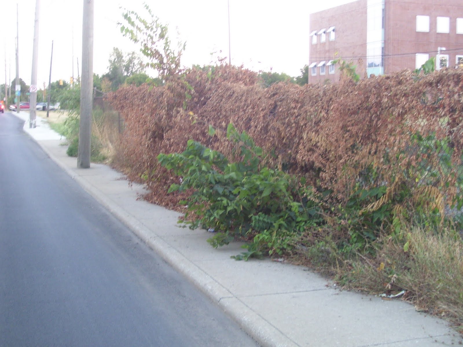 But if you would make a decision to not reconstruct this sidewalk because the surface is in good shape, wouldn't you recognize that the vegetation blocking the sidewalk needs to be removed?
Sunday, August 29, 2010
16th Street improvements
Below is a link to an article in the current issue of the Urban Times about an upcoming City project on 16th Street. It appears that the project will mainly consist of resurfacing the street, with some sidewalk and curb repair/replacement. The exciting part is the ability of a group of concerned citizens being successful in convincing the City to make some substantive changes to their plans to actually improve the street from a pedestrian's standpoint, most notably by providing curb extensions at the intersection of 16th & Delaware to reduce the crosswalk distance from five lanes to three lanes. Hopefully, this will also slow the speed of traffic and further increase safety for both drivers and pedestrians at this off-set intersection.
Ironic was the mention that the citizens' group was unsuccessful in convincing the city to reconstruct the sidewalk on the south side of 16th, west of Meridian (in front of Walgreen's parking lot), because the sidewalk there was too recently constructed to merit reconstruction. The citizens' group asked that the sidewalk be rebuilt away from the curb with a tree lawn between the street and sidewalk. One might ask why the City didn't build the sidewalk that way when it was previously reconstructed. Did we just realize that sidewalks built right next to a lane of moving cars are not inviting to pedestrians? The sidewalk probably could've been rebuilt as part of the Walgreen's redevelopment at this corner in 2007. Perhaps the City decided that it was more important to have some landscaping between the sidewalk and Walgreen's parking lot, which (according to the City's website: http://imaps.indygov.org/prod/GeneralViewer/viewer.htm ) appears to be built within a foot or so of the 16th Street right-of-way line, rather than providing a ten-foot strip of landscaping as typically required by the zoning ordinance.
Across Meridian Street, the construction of the new CVS did include reconstruction of the 16th Street sidewalk at the right-of-way line to give pedestrians a slight buffer from traffic. Unfortunately, the sidewalk along Meridian Street still hugs the curb, requiring pedestrians to walk within a misstep of traffic. While it doesn't appear that there is additional unused right-of-way on Meridian Street, there is a strip of landscaping between the CVS building and the sidewalk. Why not reverse the sidewalk and landscaping to provide some buffer between pedestrians and traffic?
http://www.urbantimesonline.com/2010/08/16th-street-getting-a-makeover-between-illinois-and-central/
Wouldn't it be refreshing to have the City actually propose improvements that would improve the pedestrian environment instead of it only happening as a result of active and informed citizens catching them in time to win some changes to the plans? Take a look at the newly rebuilt sidewalk on Dr. MLK Jr. St, between 16th and 21st Streets. Right next to moving traffic and worse yet, there are utility poles right in the middle of the sidewalk, such that there isn't even space to get a wheelchair around the poles without going off the sidewalk. Does not the Americans with Disabilities Act apply to such projects?
Ironic was the mention that the citizens' group was unsuccessful in convincing the city to reconstruct the sidewalk on the south side of 16th, west of Meridian (in front of Walgreen's parking lot), because the sidewalk there was too recently constructed to merit reconstruction. The citizens' group asked that the sidewalk be rebuilt away from the curb with a tree lawn between the street and sidewalk. One might ask why the City didn't build the sidewalk that way when it was previously reconstructed. Did we just realize that sidewalks built right next to a lane of moving cars are not inviting to pedestrians? The sidewalk probably could've been rebuilt as part of the Walgreen's redevelopment at this corner in 2007. Perhaps the City decided that it was more important to have some landscaping between the sidewalk and Walgreen's parking lot, which (according to the City's website: http://imaps.indygov.org/prod/GeneralViewer/viewer.htm ) appears to be built within a foot or so of the 16th Street right-of-way line, rather than providing a ten-foot strip of landscaping as typically required by the zoning ordinance.
Across Meridian Street, the construction of the new CVS did include reconstruction of the 16th Street sidewalk at the right-of-way line to give pedestrians a slight buffer from traffic. Unfortunately, the sidewalk along Meridian Street still hugs the curb, requiring pedestrians to walk within a misstep of traffic. While it doesn't appear that there is additional unused right-of-way on Meridian Street, there is a strip of landscaping between the CVS building and the sidewalk. Why not reverse the sidewalk and landscaping to provide some buffer between pedestrians and traffic?
http://www.urbantimesonline.com/2010/08/16th-street-getting-a-makeover-between-illinois-and-central/
Wouldn't it be refreshing to have the City actually propose improvements that would improve the pedestrian environment instead of it only happening as a result of active and informed citizens catching them in time to win some changes to the plans? Take a look at the newly rebuilt sidewalk on Dr. MLK Jr. St, between 16th and 21st Streets. Right next to moving traffic and worse yet, there are utility poles right in the middle of the sidewalk, such that there isn't even space to get a wheelchair around the poles without going off the sidewalk. Does not the Americans with Disabilities Act apply to such projects?
Monday, August 23, 2010
Pedestrian Safety Action Plan
Comprehensive study of pedestrian traffic fatalities and severe injuries in New York City:
http://s3.amazonaws.com/nytdocs/docs/458/458.pdf
UPDATE: 25-Aug-2010
This is a pretty thorough analysis of accidents involving death or severe injury. While it focuses much of its energy on pedestrians, it does analyze the rate of overall traffic deaths among all street users and determines that New York City is the safest city in the U.S. as far as traffic deaths are concerned. It adjusts for the surge in daytime population in Manhattan to stress that although the raw number of deaths and injuries is high, the rate per 100,000 population is quite low.
I believe that it alludes to NYC being even safer for pedestrians than the rate of death and severe injury per 100,000 population would imply, because there is actually a much higher rate of walking among the population there, among commuters, residents, and tourists. I've always wanted to see a study that attempts to compare pedestrian safety among U.S. cities by estimating something like miles walked per 100,000 population and using that to determine the actual likelihood of being killed or injured in a collision. My hunch has been that such a study would find that older, more dense cities, where walking is more common, are many times safer to walk in than our newer, lower density cities. It might also be interesting to have a study that factored in death or injury due to crime. If anyone is aware of such a study, please provide a link or other direction.
http://s3.amazonaws.com/nytdocs/docs/458/458.pdf
UPDATE: 25-Aug-2010
This is a pretty thorough analysis of accidents involving death or severe injury. While it focuses much of its energy on pedestrians, it does analyze the rate of overall traffic deaths among all street users and determines that New York City is the safest city in the U.S. as far as traffic deaths are concerned. It adjusts for the surge in daytime population in Manhattan to stress that although the raw number of deaths and injuries is high, the rate per 100,000 population is quite low.
I believe that it alludes to NYC being even safer for pedestrians than the rate of death and severe injury per 100,000 population would imply, because there is actually a much higher rate of walking among the population there, among commuters, residents, and tourists. I've always wanted to see a study that attempts to compare pedestrian safety among U.S. cities by estimating something like miles walked per 100,000 population and using that to determine the actual likelihood of being killed or injured in a collision. My hunch has been that such a study would find that older, more dense cities, where walking is more common, are many times safer to walk in than our newer, lower density cities. It might also be interesting to have a study that factored in death or injury due to crime. If anyone is aware of such a study, please provide a link or other direction.
Wednesday, April 14, 2010
Pedestrians struck on sidewalk
According to multiple news reports, two teenage girls walking along the sidewalk on the 2800 block of North Keystone Avenue were struck by a drunk driver Tuesday evening. The girls were severely injured and are currently hospitalized. Initial reports indicate the driver, with prior DUI convictions, who fled the scene but was apprehended shortly thereafter, is suspected of being intoxicated. Obviously, it would appear that the driver is completely responsible for this horrific tragedy. Our thoughts and prayers are with the girls and their families and friends.
However, being familiar with this street, I can't help but wonder whether a different street design could have possibly prevented these girls from being victims of this collision. Anyone who has walked this stretch of Keystone Avenue likely remembers that it is not designed to be safe or inviting for pedestrians. Sidewalks are immediately adjacent to the four-lane street, which does not permit parking on either side of the street. Although this is not an extraordinarily wide street (the lanes appear to be 10-11 feet wide), vehicles seem to typically drive in excess of the posted 35 MPH speed limit, probably because there is little to nothing of interest along or adjacent to the street to provide a natural cue to slow down.
What if the sidewalk was not directly adjacent to the street? What if pedestrians were not required to walk within a couple of feet of speeding vehicles, with nothing but a concrete curb of six inches in height or less? What if the sidewalk was separated from the street by a tree lawn? What if a tree would have been in the path of this driver and either stopped or slowed his vehicle before reaching the sidewalk?
I'm not proclaiming that if the street/sidewalk were designed differently, that this tragedy would have been avoided, but it very well might have. Quite frankly, with the widespread application of this street/sidewalk design throughout Marion County, I'm surprised that we don't hear about more pedestrians being struck. Imagine walking two abreast on a 5-foot wide sidewalk. To prevent constant shoulder/elbow bumping, one person needs to be walking just inches from the curb. One misstep, one dizzy spell, one unexpected crack in the sidewalk, could lead to a pedestrian instantly falling into the path of a moving vehicle with little to no time to react. Of course, the infrequency of such collisions could likely have a significant correlation with the fact that very few people use these sidewalks. Walking along sidewalks such as this one are typically only done by those with no other choice: no car and no other path to get where they need to go.
The solution is simple: build all sidewalks with a buffer from moving traffic. Typically, a landscape strip with trees is ideal, not only to provide a physical separation, but because it makes the street corridor more attractive to pedestrians and drivers alike and raises adjacent property values, along with all the environmental benefits. (Regularly used on-street parking can also provide a safety buffer between pedestrians and moving cars.) The Indianapolis-Marion County codes actually support the idea that sidewalks should be located with a buffer from the street, however, the City continues to build sidewalks similar to the one on Keystone Avenue.
The City is gearing up for a complete reconstruction of West 38th Street, between High School Road and I-65. The project will include construction of new sidewalks on both sides of 38th Street, but they will be immediately adjacent to the curb, forcing pedestrians to walk just a matter of inches from cars regularly traveling at 40-45 MPH, often faster. Although most of this corridor currently lack sidewalks, several portions actually include sidewalks that are buffered from the street, all of which will unfortunately be destroyed, regardless of their current condition, so that sidewalks can be rebuilt uniformly located right next to the street.
Why is the City doing this? I wish I knew. Maybe it's a buck or two cheaper to pour the sidewalk concrete right next to the curb because you only have to frame in on one side, rather than two. Although that would seem like a ridiculous reason to build an unsafe, unattractive, uninviting sidewalk, I can't think of any other reason. It's not for lack of available dedicated public right-of-way. A quick check of the General Data Viewer on the City's website shows that there is plenty of space in which to set the sidewalk back from the roadway. (The City's construction plans show that 38th Street is not being widened beyond its current curblines. It is only being reconstructed.)
So, while continually paying lip service to the idea of creating a more sustainable city conducive to alternate transportation, the City will take yet another step backward by destroying useful sidewalks and wasting money building sidewalks that will only be used as a last resort by the poor and downtrodden, furthering the belief that "Hoosiers love their cars" and they just wouldn't have it any other way.
However, being familiar with this street, I can't help but wonder whether a different street design could have possibly prevented these girls from being victims of this collision. Anyone who has walked this stretch of Keystone Avenue likely remembers that it is not designed to be safe or inviting for pedestrians. Sidewalks are immediately adjacent to the four-lane street, which does not permit parking on either side of the street. Although this is not an extraordinarily wide street (the lanes appear to be 10-11 feet wide), vehicles seem to typically drive in excess of the posted 35 MPH speed limit, probably because there is little to nothing of interest along or adjacent to the street to provide a natural cue to slow down.
What if the sidewalk was not directly adjacent to the street? What if pedestrians were not required to walk within a couple of feet of speeding vehicles, with nothing but a concrete curb of six inches in height or less? What if the sidewalk was separated from the street by a tree lawn? What if a tree would have been in the path of this driver and either stopped or slowed his vehicle before reaching the sidewalk?
I'm not proclaiming that if the street/sidewalk were designed differently, that this tragedy would have been avoided, but it very well might have. Quite frankly, with the widespread application of this street/sidewalk design throughout Marion County, I'm surprised that we don't hear about more pedestrians being struck. Imagine walking two abreast on a 5-foot wide sidewalk. To prevent constant shoulder/elbow bumping, one person needs to be walking just inches from the curb. One misstep, one dizzy spell, one unexpected crack in the sidewalk, could lead to a pedestrian instantly falling into the path of a moving vehicle with little to no time to react. Of course, the infrequency of such collisions could likely have a significant correlation with the fact that very few people use these sidewalks. Walking along sidewalks such as this one are typically only done by those with no other choice: no car and no other path to get where they need to go.
The solution is simple: build all sidewalks with a buffer from moving traffic. Typically, a landscape strip with trees is ideal, not only to provide a physical separation, but because it makes the street corridor more attractive to pedestrians and drivers alike and raises adjacent property values, along with all the environmental benefits. (Regularly used on-street parking can also provide a safety buffer between pedestrians and moving cars.) The Indianapolis-Marion County codes actually support the idea that sidewalks should be located with a buffer from the street, however, the City continues to build sidewalks similar to the one on Keystone Avenue.
The City is gearing up for a complete reconstruction of West 38th Street, between High School Road and I-65. The project will include construction of new sidewalks on both sides of 38th Street, but they will be immediately adjacent to the curb, forcing pedestrians to walk just a matter of inches from cars regularly traveling at 40-45 MPH, often faster. Although most of this corridor currently lack sidewalks, several portions actually include sidewalks that are buffered from the street, all of which will unfortunately be destroyed, regardless of their current condition, so that sidewalks can be rebuilt uniformly located right next to the street.
Why is the City doing this? I wish I knew. Maybe it's a buck or two cheaper to pour the sidewalk concrete right next to the curb because you only have to frame in on one side, rather than two. Although that would seem like a ridiculous reason to build an unsafe, unattractive, uninviting sidewalk, I can't think of any other reason. It's not for lack of available dedicated public right-of-way. A quick check of the General Data Viewer on the City's website shows that there is plenty of space in which to set the sidewalk back from the roadway. (The City's construction plans show that 38th Street is not being widened beyond its current curblines. It is only being reconstructed.)
So, while continually paying lip service to the idea of creating a more sustainable city conducive to alternate transportation, the City will take yet another step backward by destroying useful sidewalks and wasting money building sidewalks that will only be used as a last resort by the poor and downtrodden, furthering the belief that "Hoosiers love their cars" and they just wouldn't have it any other way.
Tuesday, September 15, 2009
Michigan Road & Interstate 465
View Larger Map
Recently driving through this interchange a couple times during the morning and afternoon peak periods raised a few questions for me. In the afternoons, it appears commonplace for traffic exiting from Eastbound I-465 to Michigan Road to back up quite some distance onto the mainline of I-465. Traffic sailing by at the speed limit in the left and center lanes, with traffic at a standstill, or stop and go in the right lane doesn't seem very safe, considering there will always be those drivers that need to exit, but don't realize, or don't care that they need to get to the right lane sooner. There's also those drivers unwittingly in the stopped right lane that don't wish to exit. These drivers will often attempt to move to the center lane to bypass the stop and go traffic, which also presents safety concerns.
Considering that Michigan Road was widened and the exit ramps rebuilt in the past couple years, couldn't this problem have been avoided? One solution would be a wider (more lanes) and longer (more lanes sooner with a longer queue area) exit ramp.
But I wonder if this problem highlights a bigger problem with Central Indiana freeway/expressways, that being the relative sparsity of interchanges. Consider, for drivers traveling east on I-465, the next exit after Michigan Road is Meridian Street, which is identified as being five miles away. For traffic that has traveled east on I-865 from southbound I-65, Michigan Road is the first exit after Zionsville (SR 334?), a distance of what, eight miles? Is there just too much traffic being funneled through this interchange?
Does INDOT have plans to add an interchange between Michigan and Meridian, at say Township Line Road or Ditch Road?
How about an interchange somewhere on I-865 (the "dogleg")?
View Larger Map
I suspect that folks in that area (Traders Point vicinity) might wish to preserve the ultra low-density, rural character of the area, but if subdivisions continue to develop west of Michigan Road and north and south of I-865, I would think that another interchange would be inevitable. I'm all for channeling growth toward existing infrastructure and preserving the development pattern of truly unique and historic rural areas, but that infrastructure has to be able to safely accommodate it. With virtually zero public transportation in this area, I doubt that the existing automobile infrastructure will keep pace with demand, as the backups at the Michigan Road interchange demonstrate.
Since I mentioned public transportation, let's shift gears from the Interstate down to the surface street. What is one to infer from the fact that the complete rebuilding and widening of Michigan Road from 86th to 96th Street did not include sidewalks, but yet the portion of the project north of 96th Street (Hamilton County) included sidewalks on both sides of the street? Michigan Road south of I-465 is not a state road and is wholly under the control of the City of Indianapolis - Marion County. North of I-465, this is U.S. 421, which although named a U.S. Highway, is under the authority of INDOT.
View Larger Map
There is very limited bus service on IndyGo Route 34 on Michigan Road from 86th Street to 96th Street. There is no bus service north of 96th Street. Interestingly, or sadly, short "islands" of sidewalk were constructed at some of the intersection corners, but what's the point? They don't allow anyone to walk along Michigan Road and they don't connect to anything east or west of Michigan Road. Since there are pedestrian signals, if you're fleet of foot, I suppose you could exit the bus and cross the street and reboard going back the opposite direction if you were just sightseeing along "Ye Olde Michigan Road".
View Larger Map
But seriously, how does a project like this occur in the 21st century in an urbanized area, where millions of dollars are being spent annually creating "pedestrian plans", "multi-modal design guidelines" and "rapid transit studies"?
Monday, September 14, 2009
Ducking along sidewalks
A certain blogger, let's call him me, took a walk this evening through a couple neighborhoods, let's call them the Old Northside and Cottage Home. Apparently being two of the city's most desirable neighborhoods, each located on the edge of downtown, one might expect to find the best pedestrian environment that the city has to offer. And that might actually be the case. But I have to say that I was surprised at the number of trees hanging over the sidewalk in desperate need of trimming. Sure, I'm over 6' tall, but I'm not like Greg Oden; I'd be a point guard at best in the NBA. So surely the experience of having to duck routinely to walk down the sidewalk without getting poked in the face is not unique to me. I'm accustomed to experiencing this in other neighborhoods of lesser prestige and cachet, if you will, but someone how I though these neighborhoods, where people presumably use the sidewalks and presumably are more civic-minded, engaged, and active in their communities than average, would be different.
I found this city ordinance that obligates property owners to trim trees, shrubs, and other vegetation from overhanging the sidewalk and other portions of the public right-of-way, but I would have to say that this is certainly not being enforced or communicated to the public with any regularity.
Sec. 701-6. Duties of property owner.
I found this city ordinance that obligates property owners to trim trees, shrubs, and other vegetation from overhanging the sidewalk and other portions of the public right-of-way, but I would have to say that this is certainly not being enforced or communicated to the public with any regularity.
Sec. 701-6. Duties of property owner.
(a) The owner of any private property in Marion County which borders or lies adjacent to any public street, alley, right-of-way, place or park and upon which any trees or flora may be standing shall trim or cause such trees or flora to be trimmed, either at the property line, or to a clear height of at least eight (8) feet above the surface of any abutting right-of-way or place, and fourteen (14) feet above any public street or alley. All branches or parts thereof which overhang any portion of a public street, alley, right-of-way, or place, or which obstruct or interfere with the passage of light from any street lighting system, shall be trimmed or cut. No person shall plant or maintain any tree or flora so close to any property line as to obstruct the vision or free passage of pedestrians or motorists along the streets or public right-of-way. The consolidated city or its contractual agent or agents may enter upon private property to do such cutting or trimming as may be necessary to remove any offending and obstructing tree or flora that is prohibited by the provisions hereof.
(b) An owner shall, and the consolidated city may, remove from flora all dead, decayed, broken or dangerous limbs, branches or parts thereof or any that overhang or are close to any public street, alley, right-of-way, or place, and, when any such flora is dead, the owner shall completely remove the same, or after notice to and failure of the owner so to do, the department or its lawful agents may cause such removal and charge the cost thereof to the owner in accordance with the procedures hereinafter provided.
Subscribe to:
Posts (Atom)